E-Networking Research and Development (ENRD) in collaboration with Japanese team members have developed and installed trekkers tracking system as a pilot in Annapurna region of Nepal. The major financial support for the pilot project came from Asia Pacific Telecommunity based in Bangkok. Annapurna Conservation Project is the implementing partner.
Many Nepali and foreign trekkers hike in the mountain trails to see the natural beauty of the Himalayas. Many of them get lost occasionally and some trekkers die in the mountains. After the installation of the human tracking system, the trekkers will be much safer.
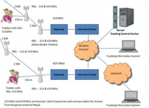
NTTS system’s flow diagram
The trekkers will be given a small device like a pen drive called eTag that will help to track them. There will be small solar powered relay stations called Repeater Relay Station (RRS) at specific places along the trail. The RRS receives the ID of the eTag carried by the trekkers and will relay the position of the trekkers once they pass through it. The position of the trekkers can be viewed through the Internet.
The trekkers can give the eTag number to their family or close relatives or friends if they want them to be tracked. Thus the families or friends of the trekkers back home also can track them through the Internet by the ID number of the eTag. Thus it will help to track the trekkers just in case they get lost.
In case of emergency, the trekkers can press red SOS button in the eTag for 5 seconds. The eTag will immediately send an emergency signal to the control room of ACAP office. The person on duty at the ACAP office can send message to the relatives by email and call to police and rescue organizations for further action.
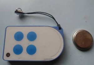
E-tag
Trekkers don’t need to pay any extra fee for the eTags. They just need to deposit US$15 when they will be issued eTag along with the trekking permit. The money will be given back at the collection centres after the trekkers return the eTag.
This system is different from the GPS and GPRS tracking system that is available in the market. The following diagram shows the radio frequencies the Tags and RRS are using. It also shows how the information from the eTags carried by the trekkers will go to the server.
The hardware of the system was designed and tested in Japan by Japanese and Nepali team members. More works are being done to improve and customize the product according to the need of the trekkers going for trekking in the mountains of Nepal. Once the product is tested successfully, we will request the government of Nepal to install the system in other trekking routes in Nepal.
Information about the bandwidth used for the operation of radio equipment is given below.
For 315HMz TAG system, bandwidth is 100 kHz, 314.95 MHz +/-50 kHz, using one channel
For 429MHz relay system, bandwidth is 8.5 kHz in a channel, 429.250MHz to 429.7375MHz 40 channels in 12.5 kHz step. The system is using 3 channels multi channel access method, 8, 25 and 36 in 40 channels. Channel 8 – 429.3375MHz, channel 25 – 429.550MHz, and channel 36 – 429.6875MHz.
TAG to RRS in one way communication: 315MHz
RRS to/from RRS in two way communication: 429MHz
RRS to/from Router G/W in two way communication: 429MHz
System configuration is as follows.
TAG has 315MHz transmitter
RRS has 315MHz diversity receiver and, 429MHz transmitter and receiver
Router G/W has 429MHz transmitter and receiver.
Funding Agency: Asia Pacific Telecommunity, Bangkok, Thailand
Partner organizations/institutions
1. E-Networking Research and Development
2. Japan International ICT Association (JIIA)
3. Nihon Software Engineering Company
4. Nomura Engineering Company, Japan
5. Annapurna Conservation Project, Nepal
6. Nepal Tourism Board, Ministry of Tourism
Note: for more detail about the project you can visit NTTS official website ntts.org.np